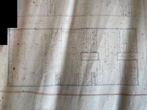
August 17, 1868 – William Heeser began conducting a land survey of the town of Mendocino, by order of the County Judge. His survey map was recorded with the Mendocino County Clerk, James Fowzer, on March 18, 1869.
Heeser was a land surveyor and mapped most of Mendocino and its surrounding land. Written in Heeser’s own hand, this document also contains a list of property owners, including the “Mendocino Mill Company,” a short description of each lot, and the area of each parcel. The principal areas surveyed were Main, Lansing, Ukiah, and Kasten streets and totaled 72 acres.
Walking Tours of Historic Mendocino – Join our expert docents for a stroll and lively commentary. You’ll pass by early pioneer homes, historic meeting places, and buildings that make up the the Mendocino Historic District.