As a docent at the Kelley House Museum, I love looking at old maps of Mendocino. While there are many to peruse in the archives there, I made an internet discovery that has entertained me for hours. Google “Historic Map Works” and “Mendocino County 1954” and you will see extremely detailed maps of our county fully indexed by location. On big tracts, especially in rural areas, the landowner’s name is shown. Highway 1 has not yet been cut through “Mendocino City”.
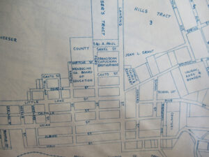
Did you know all the east-to-west streets in town on the ocean side of Highway 1 are named after geographic locations and all the north-to-south streets are named after pioneer settlers? Today’s Heeser Drive is the exception, but it didn’t exist as a named road in 1954 . . . that was all part of the Heeser Tract.
Some streets have vanished. Behind Mendocino High School, about where the bleachers sit by the baseball field, there was Comptche Street going between Kasten and Ford Streets. North on Lansing, just past the Catholic Church, was Sanel Street going west one block to Ford Street.
East of Mendocino City up Little Lake Street was Grindle Street, now Hills Ranch Road. The 1954 map shows two more roads parallel to Grindle, Winthrop and High Streets, all connected by Spring Street. A planned community subdivision never built upon? Not a quarter mile east on Little Lake Street were five more streets on the Metsker Company map that disappeared. On the north side of the road were Keans, Hubble, Fir, Bush and another Pine Street, about where Gurley Lane is now. Where did the cartographers get their information? The County Assessor’s Office?
Turning off the computer and going to good old-fashioned print-on-paper resources, I gathered the following tidbits of street history. By the late 1800s, Mendocino City was petitioning the county for right-of-ways through properties for a county-funded road. Local citizens would subscribe (donate) money to make this happen. Gordon Alley was between School and Howard streets. Lemos Lane ran between Ukiah and Albion streets. Law Lane ran uphill from the east end of Mendosa’s parking lot up to the cemetery. Bridge Street came up from Big River to town. Denslow Street ran through the middle of the Mendocino Art Center.
In the 1960s, Highway 1 was improved and the eastern part of Pine Street was flattened, as was everything east of the Grammar School. The government bought up properties and sold off houses that could be moved. The state highway department didn’t want to admit they “displaced” homeowners in 1964. They called it “Progress!”
Whenever I do research on one topic, I get distracted by other history tidbits I discover in the archives. In the news of 1881, William Kelley said he expected to take 1,000 fish from his pond at the Kelley House. He said many fish had been exercising and displaying jumping capabilities and that yellow catfish and trout would be removed. I hope folks got to eat them. Also, in 1893, 1,100 cypress trees were placed along the north and west sides of the athletic fields at the high school as windbreaks. You can see the survivors 113 years later still growing there today.
Like to find out more about Mendocino? Join the Kelley House guided walking tours, Saturday and Sunday at 11 a.m.. Whether you are a first-time visitor or a lifelong resident, you’ll learn surprising details (and even some secrets!) about the people, historic architecture and community spirit of this pioneer town. For more information, visit kelleyhousemuseum.org/walking-tours.