It’s always interesting to go back to the beginning. We like to know where it all started, what it was like before, how it was different from today. Perhaps that’s why books and movies with historical settings are popular. Authors and screenwriters provide us with wonderfully detailed pictures of an earlier world with compelling drama, interesting plot twists and intriguing characters we want to know more about.
Without a time machine to physically transport us back, those of us who want to know more about the real past must recreate it with whatever fragments have been left behind. One of our best time travel techniques is an original document. A faded photo, a carefully folded deed, the curled up map are items infused with memories and clues of what came before. There’s a strange vibration around these old objects, something that people who are afflicted with “the historian’s malady,” find utterly irresistible.
Which is why I was so excited last summer when Vince Johnson presented the Kelley House Museum with a box of old maps. Mr. Johnson has generously shared his finds with us for several years, including vintage bottles and rare correspondence and documents from Mendocino’s early life.
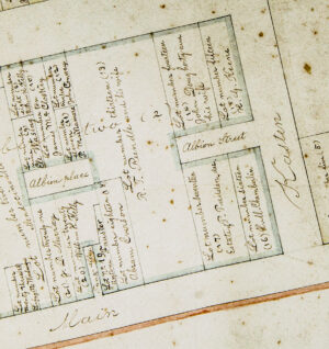
This latest gift included several rolled up survey maps by William Heeser, aka “Mr. Mendocino,” drafted on thick, heavy paper that is now so browned with age it resembles a grocery bag. The largest of the maps, a portion of which is pictured here, shows Mendocino as it was in 1867, twenty-five years after it began. While surveyor Chuck Evans had previously re-created the Mendocino survey from Heeser’s written notes, and we had published that drawing in a volume of the Mendocino Historical Review back in 1977, what we were looking at here was the original document!
Drawn with magnetic north straight up, it shows how the peninsula was divided so many years ago into lots, some for businesses and some for residences. While there is no indication of hills, forested areas or streams, it does include in beautiful cursive script the names of the property owners, some of whom may be familiar even to people not so buggy with historical obsessions.
Heeser’s own name appears frequently on the survey, as he had purchased most of the area west of Lansing from William H. Kelly in 1858. (At that time, Kelley’s name was spelled with one “e.”) Over the years, he subdivided these large parcels into smaller plots where newcomers could build a house with a picket fence around it and room for a cow and chickens in the back yard.
Kelly’s name is all over the map, too, because he had bought the peninsula from William Kasten back in 1854. When he later sold it to Heeser, he retained a large parcel, Number 16, on the north side of Main Street where he built in 1861 his own house, now known as the Kelley House Museum. He owned several other parcels, including Lot Number 20 on western Main Street, which was the site of his now-gone general store.
The street names on this old map are recognizable today. There’s Main, Kasten, and Heeser Streets, but all the little ones on the west side of town, such as Carlson, Osborn and Rundle, have yet to appear. Ukiah Street is in two parts, with a gap in the middle where Heeser’s house on Lot Number 17 was located.
Albion Street was discontinuous, too, and there was no Albion east of Kasten. The short west end of it was called Albion Place, and fronting on it was a most unusual property — Lot Number 9, owned by Eli Wa Sing. The Temple of Kwan Tai, still in existence, was later built here. It was rare for a Chinese person to own property in California in the 1860s, as there was a lot of anti-Chinese sentiment all over the state. The town of Mendocino, while not devoid of racial tensions, seemed to offer some tolerance to its many Chinese residents and business owners.
One of the intriguing notations on the map are the words TANK ALLEY, found on a small rectangular finger of land sandwiched between William Kelly’s Main Street store and Lot Number 19 to the east. What’s this all about? No property owner or lot number is shown. It’s just 13 feet wide and about 80 feet deep, ending at the back part of Kelly’s adjoining lot. I have a theory about this odd little place, but I still need to do more research. What I do know is that there was a building shoe-horned into this 1,040 square foot space probably in the 1970s, and that there was a store here called Red Rooster Records that specialized in hard to find music from all over the world, with an expert staff led by DJ Gerard Eisenberg. In recent years, it housed Spark, a store that sold hand-crafted glass pipes, but is at this time vacant.
Thanks to Vince Johnson, this special document now resides in the Museum’s climate-controlled vault. Our multi-talented volunteer, Drew Jackson, was able to coax it from its stiff, rolled-up state into something flat enough to photograph and soon those photos will be available on our website. Until then, you can come to the Kelley House Research office and personally inspect this and other cartographic treasures between the hours of 1:00 pm and 4:00 pm, Monday through Friday. Our address is 45007 Albion Street in Mendocino. Or contact us by phone at (707) 957-2810, or email us at [email protected].