Naming places is something people do to orient themselves and connect with their environment. In our homes, we have “Grandma’s chair” or the “back forty.” Moving outwards, our neighborhoods have local designations, too. These hyper-local labels often commemorate events, such as “Two-Buck Turn” on Little Lake Road east of Mendocino. It was given that peculiar name because Witherle Atwood, who was not an experienced deer hunter, surprised everyone by bagging a four-pointer at a sharp turn on the road – TWICE in two days.
While such names aren’t often recorded on official topographic maps, you can’t help but notice these maps seem to have a label for many little valleys and the streams running through them. There’s Slaughterhouse Gulch, which drains into Agate Beach, north of what was once the Spencer Hills ranch. It was called that because Mr. Hills used to run cattle on his property and supplied the area with fresh meat.
Recently, my interest was piqued when I came upon this June 22, 1878 item in the Mendocino Beacon: “The whistle of a new shingle mill is now heard in Mendocino. This mill is situated at Siewers’ Gulch and owned by Gray & LeBallister.” Where was this gulch? And who was Siewers?
I recognized the names Gray and LeBallister, two well-known lumber families from Mendocino’s early logging era. Indeed, there is a LeBallister Gulch right here in town, east of Evergreen Cemetery. While much of it has been placed underground, anyone coming into town via Main Street can still see a part of it as the roadway loops north of the steep ravine where its stream plunges down toward Big River Beach.
Back to Siewers’ Gulch. I checked for the location of nearby mills in a book by Alice Holmes and Wilbur Lawson called, “The Mills of Mendocino County; a Record of the Lumber Industry 1852 – 1996,” published by the Mendocino County Historical Society in 1996. According to their research, a shingle mill operated from about 1878 to 1888 just north of Mendocino in Russian Gulch Bay by Prince Gray, and LeBallister had lumber operations in this area since the 1860s. Right time period, right names. The entry notes the mill’s location in section 18 of Township17, Range 17. Yes! I can take this geographic information and look for Siewers Gulch on topographic maps, which have township and range information as well as named gulches.
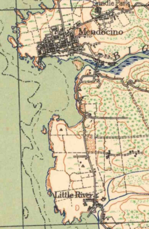
There is a wonderful online topographic map site called topoView located at ngmdb.usgs.gov/topoview/. You can type in a location and a list of all the maps available for that place will appear. When I entered “Mendocino” into the search window, a list of 18 maps came up in chronological order. The earliest one was published in 1920, and it’s a beauty. The background is a soft buff color, and the faded red and green symbols indicate areas that were cultivated (straight parallel lines), orchards (green blobs in rows), and pastureland (grassy hummock symbols).
The almost magical thing about this topoView site is that it allows you to see the old maps layered over current topographic data, satellite imagery, or shaded terrain maps. As you move the site’s transparency slider, the roads and houses on the old maps slowly transition until the current map layer is revealed. In between, the two maps are transparently aligned with one another, creating a palimpsest effect of seeing previous features at the same time as current ones. This pixilated sleight-of-hand is cartographic time travel.
The oldest map I could find for this area was 1920 and it showed no Siewers’ Gulch. Besides, it seemed pretty far away from town to hear a mill whistle blow. Taking a different approach, I tried to find out who Siewers was, since places are often named for the people living there. Success! Siewers’ story emerged as I pieced together information from various lists and databases found online and at the Kelley House Museum, including a particularly informative 1902 Beacon obituary with the poignant title, “Aged Man Dies Alone.”
William Siewers was born in 1818 in Schleswig-Holstein, Germany, serving in “the war that wrested that province from the dominion of the Danish king.” He arrived in Mendocino aboard the Brig Aeolus on March 3, 1857, to work for the lumber company as a cross-cut sawyer.
Later, he was able to purchase “the coast ranch next to the Kent place and improved and occupied it,” which would have been a requirement to receive a patent on the land from the government. A search on thelandpatents.com confirmed William had done this in 1875, three years before the Beacon’s announcement of the new shingle mill. The location of this ranch right across the Bay from Mendocino, within earshot of a mill blowing its whistle.
At the age of 63, William sold his 156-acre ranch along the Coast Road to A. Gowell, then went to live for a time with his fellow German, John Staudacher the brick maker. In 1901 he moved into Mendocino, where he died a year later of heart failure, alone in his home, at the age of 84. He now rests in Evergreen Cemetery.
The online patent map showed Siewers 1875 coastal ranch began at the Pacific Ocean, encompassed Chapman’s Point on the south side of Mendocino Bay, and stretched from the Comptche-Ukiah Road on the north to Gordon Lane on the south. An 1866 survey notes the land there as “Hilly & Broken,” i.e. full of gulches. Nowadays, we would describe the area as incredibly picturesque, and through the efforts of Grail Dawson, Betty Barber and the Mendocino Land Trust, ocean views here have been preserved since 1996 for public access as the Mendocino Bay Viewpoint. There’s a bench there, dedicated to them, so that we can sit and enjoy what William Siewers saw.
If you know of local place names that we can add to our Mendocino Atlas project, call us at (707) 937-5791 or contact curator@kelleyhousemuseum.org.